Tuesday, January 29, 2013

Oh, sunny Key West!!


A cold winter morning dawned. I had tried to make it to the office that day, but turned around after going very slow for several miles. I would have been to late for the meeting anyway.
So back home to shovel the driveway and work from the house.
In the evening we drove to Baltimore to stay at Flip's house prior to boarding a plane in the wee hours south. South to Florida, then further south to the "most Southern" south the US has to offer! As we boarded the jet in BWI a thermometer on the jet-way read 12 degrees F.

Friday

The jet tipped wing as we came in for the final descent into Key West. Below us the turquois water shone blue, able to see all the shallow features on the ocean surface, and the eroded bottom. Closer down we're able to see para-sailers, boaters, even some kayakers around an undeveloped island. The runway is short and the jet slams down quickly and roars it's brakes to slow us down. The warm sun beats down on us as we cross the tarmac under a fake southern most point statue.
We grab a taxi and head to Chelsea House, right off of Truman Ave a couple blocks north of the infamous Duval St. We drop our bags and change into much more appropriate attire: shorts and sunglasses! We mosey down the southern end of Duval, fascinated by the roosters, architecture, and mostly the warmth.


We continue our walking tour down to the Southern most Point and see a line 30 long to get pictures with it and decide that is really not on the list of things that need to be done today! We continue down Whitehead St towards the other end of town, passing Hemingways house, a light-house, and row after row of gorgeous houses. We stumble upon Blue Heaven and circle back to Duval. The touristic feel rackets higher and higher the further we move down Duval. Conch Train Tours pass frequently, as well as other tour buses of a variety of shapes and sizes. Malory Square feels like an amusement park with all the tours and people fresh off the cruise ship.


We make it down to Sunset Pier for a much needed refreshment and seat. We take in the sights and soak up the sun, watching boats travel by, as well as lazily floating pelicans catching thermals. I've been here before, but off a cruise ship there is a pervasive clock ticking as the time spent on shore is too short. I'm glad I didn't get here by boat again.
Tired from a late night and an early morning we decided to make it an early night and try to be well rested for the fun weekend ahead. We went a few blocks over to El Siboney, a Cuban restaurant, and enjoy a fantastic meal.

Saturday
A leisurely awakening in our nice room at the Chelsea House. Our room opens on the pool area with a patio area directly in front. A continental breakfast is served right outside our door, so it's easy to grab a cup of coffee and prepare for the day at the table on our patio.


It's still very early so we decide to stroll down and see the water, as we were up before breakfast this morn - early risers! All the shops were closed, except a coffee shop. Thus armed we made our way down to the southern most point to find it crowd-free and had ample opportunity to snap a few pictures.
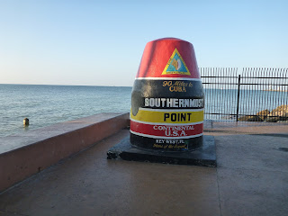
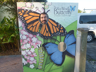

It IS Key West, ya know. Gotta let your butterfly fly...

We headed back to the hotel and got suited up for the day. The island is so small that you can easily walk everywhere. Many people opt to rent scooters, bikes, golf carts, tour buses, and rickshaws. We hoofed it everywhere!
First we headed over to all the boutique shops on the "better" end of Duval (I say that because the atmosphere was much more accommodating and much less drippingly tourist trap feeling as downtown Duval feels). We wandered around hitting the good shops just enjoying life! We made our way over to Whitehead St and walked the length of an art festival that had the street closed. We found a local craft brewery too!


Next we did the hike to Fort Zachary Taylor, the beach was great, the clearest water in Key West. It did not disappoint! The park was very nice. The concessions were what you would expect at a state park - I got a hot dog, yummy!


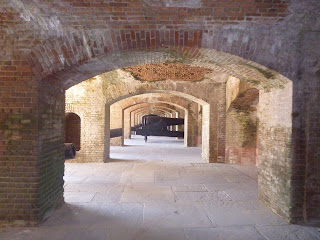
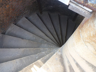


After exploring the beach and then the Fort itself we head back into town, stopping at a few more stores before heading back to the room and getting ready for dinner. That evening we went to a tasty little French place called Banana Cafe and had another excellent meal! Key West is the place for foodies! There are so many nice restaurants around! There's plenty of bar food as well, but there is a very large variety of fine and just plan good dining too!
After all the walking and exploring we decided to get some rest for another full day to come!

Sunday

We had plans to go kayaking at noon so we had the morning to do some eating and exploring again. We walked down to the harbor walk and down Duval a couple times after we'd stopped at La Creperie for an awesome breakfast. We were up early and the town was just stirring. People are up early washing their side-walks and preparing for the influx of consumers arriving from hotels and cruise ships.
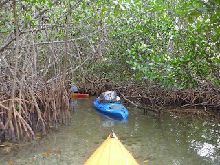
We got a ride from the tour company to Stock Island and paddled out from the harbor there. The location seemed sketchy, nestled between a taxi cab garage and crab fishermans compound. If I had to do it again I would have gone with one of the other tour companies that put you on a boat and take you out to an undeveloped island. The detritus and trash floating by the dock wasn't pleasant. The guide and owner was very knowledgeable and took us through the mangrove creeks and explained all the different aspects and ecology of the environment. The wind was whipping so we were not taken out the other side of the island. There were a few children in tandem kayaks with their parents and the wind may have blown them away.
Monday
Our flight left at 2pm so we had an awesomely lazy morning. We had breakfast on the water, we went back to a shop to buy some stuff for the wedding after mulling over whether we really wanted it or not. We walked up to the AIDS memorial for one last look at the ocean, to feel the warm breeze, to watch the pelicans tandem dive for fish. At the airport we sat in a sunny outside courtyard, our feet in the sand, enjoying every last second of our short vacation south...


After the 2.5 hour tour was over we were dropped back at the Chelsea House to wash off the salt spray and get ready to go out to a nice restaurant. This was our engagement party to ourselves! We ate at Michael's and what a great place that was! We were sat way back in a romantic corner, surrounded by bamboo in a outside courtyard. The food was excellent, as was the service. We headed down to meet a couple people and have a few beers downtown. We did the bar crawl from Fogery's to Irish Kevin's to Durty Harry's. Each place had good features and we got to experience "that end" of Key West after dark. After a few hours, we headed back down Duval to "home". As this was a Sunday night the place wasn't chock-full and nuts like it gets on some Saturdays, I hear. It was a good way to get the lay of things for the next time we come to Key West, and we're definitely coming back!t La Creperie for an awesome breakfast. We were up early and the town was just stirring. People are up early washing their side-walks and preparing for the influx of consumers arriving from hotels and cruise ships.

We got a ride from the tour company to Stock Island and paddled out from the harbor there. The location seemed sketchy, nestled between a taxi cab garage and crab fishermans compound. If I had to do it again I would have gone with one of the other tour companies that put you on a boat and take you out to an undeveloped island. The detritus and trash floating by the dock wasn't pleasant. The guide and owner was very knowledgeable and took us through the mangrove creeks and explained all the different aspects and ecology of the environment. The wind was whipping so we were not taken out the other side of the island. There were a few children in tandem kayaks with their parents and the wind may have blown them away.


After the 2.5 hour tour was over we were dropped back at the Chelsea House to wash off the salt spray and get ready to go out to a nice restaurant. This was our engagement party to ourselves! We ate at Michael's and what a great place that was! We were sat way back in a romantic corner, surrounded by bamboo in a outside courtyard. The food was excellent, as was the service. We headed down to meet a couple people and have a few beers downtown. We did the bar crawl from Fogery's to Irish Kevin's to Durty Harry's. Each place had good features and we got to experience "that end" of Key West after dark. After a few hours, we headed back down Duval to "home". As this was a Sunday night the place wasn't chock-full and nuts like it gets on some Saturdays, I hear. It was a good way to get the lay of things for the next time we come to Key West, and we're definitely coming back!

Monday

Our flight left at 2pm so we had an awesomely lazy morning. We had breakfast on the water, we went back to a shop to buy some stuff for the wedding after mulling over whether we really wanted it or not. We walked up to the AIDS memorial for one last look at the ocean, to feel the warm breeze, to watch the pelicans tandem dive for fish. At the airport we sat in a sunny outside courtyard, our feet in the sand, enjoying every last second of our short vacation south...

Enhanced by Zemanta

Friday, January 11, 2013

Chapter 7 - Summit Tale

Time draws me further and further from the time I stood on top of Katahdin. I have done some long work weeks, and at home we've done some more renovation. The memories of living in the woods fade into the "did it really happen" grey. It seems like another guy did those things. I try to remember the pain I try to remember the discomfort, but as with anything hard done, the accomplishment is remembered but the blisters and bugs are the first to be forgotten.

I get such vivid images in my mind of something from the Trail. The way the light filtered through the trees, the way moss covered a rock, conversations with hikers, and even the pangs of immense hunger. The longing I feel to be re-immersed is extremely intense at times. The simplicity of the days in woods with only my longing to be home to keep me company and hours to think about it. Now home and wanting to see the bend in the Trail again, if only for a weekend or a week.

To matters at hand! I have a whole life time to wistfully think about the Appalachian Trail, and fondly!

The 100 Nile Wilderness! Sounds scary, right? Don't be intimidated, it is also one of the longest sections of easy hiking on the entire Trail. I could've done it in 3 days, but I stopped just short and did the last 3 miles after a leisurely morning, technically walking to Abol Bridge after 47 hours from leaving Monson.

But I'm getting ahead of myself. The day dawned rainy and misty. I was dreading getting wet feet at the start of a long walk I was about to begin. I had 2 days of food on me and had arranged a bucket drop at KI Rd - almost exactly 30 miles in, so two 15 mile days was the thought. I got a ride to the Trail head out of Monson with Craisin, Tex, Ranger, and Rebound. A quarter of a mile or less from the road there's a stream crossing. Though it was misty and the ground was wet my feet were dry and I was keeping it that way! I sat and removed my foot gear and waded across the cool stream. The other guys got across mostly dry. A few minutes later I come upon Tex talking on the phone! Well I guess even the edge of the wilderness gets signal. He was making arrangements to get home after the Trail was done.

The roots and rocks were in treacherous condition, I fell a couple times while trying to get off a rocky ledge (though one of those times I bounced off my backpack back to a standing position unscathed!). However, as the day wore on the fog lifted and the sun came out and began drying the slick rocks. There were a few more streams crossings, some that required show remove, most did not.
No large hills were in my way and I made good time over the small ups and downs, especially after the dazzling sun came out and made the day beautiful. Towards the end of the day I decided that I might as well push a bit over the 15 miles I had thought about originally since there weren't any campsites close to where I'd be getting my food stash. This did mean a 2000 foot climb, but it was actually really easy, nothing too strenuous for a hiking machine!

I climbed Barren Mountain, the wind kicking up and the temperature dropping noticeably. Cloud Pond Lean-to, though far off the Trail, was my destination. Beautifully situated next to a tarn, the trail sidled up next to a cliff and a lake and required board-walk to get around the cliff face to the shelter. The camping spots, even for a hammock, were very limited. Behind the shelter there was a dense stand of fir trees that I hung the hammock; the trees were so small that I wrapped the hanging drop around three on each side so I wouldn't bend in and have my butt on the ground! The wind whipped and I put on every bit of clothing I had glad I had it all! Ranger and Rebound also hung close by bundled up as well. The shelter itself offered no protection from the wind, in fact facing the breeze seemed to catch the air and was colder. After a hurried dinner I hopped in my gloriously warm sleeping bag to read some Harry Potter before drifting of swaying in the wind listening to it blow through my fir stand.
The next morning began bright and sunny, though still cold. The best thing for cold is to start hiking! Over Fourth Mountain and through a bog, over Third and through another bog! These area were incredibly interesting and beautiful with the sun making the green stand out brilliantly.
Soon enough I was at my bucket, making my pack heavy with 4 more days of food. Thus prepared I hiked into Gulf Hagas. The day was still young and I was feeling good! The last mountain between Katadihn and I could either be done today or tomorrow. I decided to go as far as I could and see if I could get to the other side of White Cap, though that would be a 26 mile day. I questioned my decision as I made my way past Tappan Campsite, but the Trail was stairs, though so steep but not difficult. MATC (Maine Appalachian Trail Club) does a wonderful job maintaining this section, between the stairs and the water culverts, all made by hand to prevent erosion, I was very impressed.
Additional motivation to crest White Cap was I heard that this was one of the few spots in the wilds that cell reception was good. I wanted to let Cara know I was doing well. I stopped on the top and the wind began to chill me immediately, but I got a call through and spoke for a few minutes before heading off and down the last few miles of the day. As I rounded a bend, into the afternoon sunlight, I recevied a clear and unabashed view of Katahdin. This was in fact the same mountain I had seen from the Bigelows - I just hadn't been able to confirm it. This was Katahdin! Not the point of my journey, but the end. Like Frodo seeing Mt.Doom, my burden would soon be lifted, my journey at it's end, my precious lost. (nerd alert)
Still, it seems so far. But the lay of the land seems flat. And thinking back to other times on the Trail being able to look back and see where I began and ended in a single day - that time looking back to see the high point in NJ, so far away that I had stood at it's base the afternoon before - or that time in the Smokies with Flip looking back at Fontana Dam and Shuckstack Firetower three days later and seeing how far we'd come - the distance wasn't great. I would be there quickly. Now was the time to reminisce, to try and capture images and keep them in my mind and in my heart. I'd never be here again most likely, almost assuredly. I would stare off into the forest or a meadow and whisper to myself "Remember this". And I do.
The next day was a day of great hiking, through pine forest with soft needle carpets, skirting lakes and following rivers. At Jo Mary Rd, a Trail Angel had left some Cokes! What a surprise, here in this supposed wilderness. On the 2nd day of hiking there was an AMC Lodge that just opened that I could have stayed at. At Jo Mary Rd there is a campground with store and showers. And a few miles later there is a Lodge at Whitehouse Landing. If one choose, one could have slept in a bed or had a shower on several occasions through this stretch of Maine.
I surpassed Whitehouse Landing, after hearing the proprietor could sometimes be on the mean side. After further contemplation  and hearing other stories, I came to the conclusion that was not the case. He just doesn't put up with the "Entitled Thru" - the hikers that expected special treatment because they decided to be homeless for a summer. I had seen the same thing over and over on this trip. People probably said the same thing about the owners of Hemlock Hollow, even though they were very kind and generous  just not to be taken advantage. I ended the day at a completely primitive campsite right by the side of a river - 28 miles from where I had started the day!
Katahdin was much closer when I got the chance to see here this day. Not quite looming yet, but getting there!
The next day was another fabulously easy day of hiking. Following a river here, and a lake shore there. All the rivers that I had to ford were not raging, as I knew they could've been. Some spots were a bit muddy and rooty, but easy to skirt around. Had I been going through here while it was raining or had been a wetter year I could see how the pace would be much slower through the wilderness. I was not here while it was wet, though, and so I flew. Another 25 mile day that I could have pushed and made it to Abol. But why pay for a campsite when I could camp for free? I hadn't seen many people in the last couple days, and was glad someone was at the shelter, he and I spoke into the late evening before turning in. I was envisioning scout troops and weekenders all over as this was Labor Day weekend, but I was thankfully wrong and received a quiet campsite with only one more night in the woods ahead of me.
From Rainbow Ledges I was able to view a cloud-shrouded Katahdin, and glad I wasn't in that fog for my summit day! I had high hopes of a good clear day to mount the Mount! From Nesuntabunt Mountain I was able to shoot a text to my parents, but no more than that. I texted them that I would wait at Abol until 1pm for them the following day if they were in the area to meet me there. Otherwise, I would be summiting Katahdin the following day and I'd try to get ahold of them from the top.
I made it to Abol Bridge with an air of excitement pervading me. Joy and accomplishment and wistfulness too. I sat there for a long time, after making a reservation for myself, Ranger, Craisin, and Rebound for The Birches for that evening with Jonathan from the ATC. My parents never came, but that was alright, I hadn't expected it but just had to be sure.


I started a very leisurely 9 miles into Baxter State Park, following a nearly level trail along the shores of the Penobscot River, watching white water rafters float down stream while I walked under old huge pines on a periwinkle blue sky day. I took my time and savored every step. Soon I got into the tourist section. I knew this when around 50 Indians (from India) asked me for directions. Next toddlers began toddling down the Trail and I knew I was nearing the end. Still the lakes and trails, woods and streams all sang sweetly to me. A day to be locked into my memory forever. I have been so, I can only say, blessed. By whatever there is out there through trial and adventures I always seemed to turn out just fine. I was never seriously injured, I never really wanted or was tempted to quit, though of course I had my low moments, I was able to have days like this!
Later, at The Birches, after dark and already bedded down, Jonathan from the ATC arrived with a cake! Trail magic on the night before Big K!
The next morning I was packed before dawn. My stuff stashed and a day bag packed. I got to the trail head and saw that a group of ten started the trail before me, I was imagining a mobbed summit - but I've been hiking for nearly give months, I can beat them up the mountain. The first couple miles of the trail to the top were great, following Katahdin Creek. The trail began to get steeper, and I soon passed the group of ten. Right at tree line Craisin caught up and we walked the rest of the way up... actually a lot of it was climbing! Up boulders and rock faces, along a incredible rock ridgeline to the tablelands. The wind blew chilly and I had to put a few more layers on. The last 2 miles was spread out before me, the summit still hidden. At last the top came into view! The celebration began in earnest! The sign I never really believed I'd see in person, I was now standing on it! Ranger and Rebound showed up quickly and we all congratulated each other, they spewed champagne all over. I got a bit of signal and got to talk to Cara for a few minutes! After pictures and lots of smiles we headed off the mountain. And that was it -the end of the trip, the summer of hiking over!
I didn't use it


The knifes edge

Coming back down
Here are the blog posts that I posted while I was hiking. They lack pictures, and overlap what these 7 parts have covered, but are more 'immediate' to where I was on the Trail.

Johnny Walker Black

Chapter 6 - Rain, Pain, Elevation Gain in Southern Maine

I was hobbled. My foot in major pain after letting it cool down at all. I would do the 'Ozzy' walk to the bathroom in the middle of the night and in the morning. Fortunately I was at Lovett's Inn for some rest and recuperation. But since I had some time to kill, and sitting around really isn't my thing I tried to help around the property as much as possible. I helped mow the lawn, refill the pond across the street, tear down an old shed, and did some dishes in the kitchen after guests ate in the dining room.
A rainbow in Franconia
While I was there Cara came and visited for a few days. This was going to be the last time I saw her until I finished the Trail, at least another 3 weeks. We had finally been getting used to being apart, at first it was hard for both of us, missing each other constantly. While we didn't like being apart, we were falling into a groove of being apart. It helped I had cell reception everyday and was able to call and chat in the evenings before bed.
While at the Inn it rained everyday, sometimes not much or for very long, but part of the day and sometimes for most of the day. The tops of the Whites obscured by clouds and lashed with rain. I picked a good week to take off. And by the ache in my foot continuing for 4 days unabated, my body needed it as well!
After the six days drew to a close I was prepared to finish the Trail. I made the executive decision to skip over the White's and come back and do them as several shorter section hikes. I have not regretted it. I would follow the same course of action had I to do it again. The section is rough, tough, and beautiful. The Trail steep and apparently in terrible disrepair in places, the AMC apparently only maintains Trails that lead from a road to their huts (the things that make them $100 a night). I heard an incredible amount of whining and complaining from thru-hikers in Maine about how terrible the AMC is and how bad the Trails were and on and on. I was dropped off in Gorham one morning and got to experience first-hand the roughness of the Trail.
The day was misty with threat of rain, as I climbed Mt Hayes. The AMC, apparently, hates the Appalachian Trail and refuses to put trail signs that have the AT mentioned. White blazes, those rectangles that lead us thru the wilderness are often neglected and the AMC only puts them once every 1/4 or more. I had heard that in a few sections in the Whites you would go for miles without actually knowing if you were on the AT. I'm not sure what they are trying to prove. But what I do know is that at the shelters they were able to have a care-taker, tent platforms, and an out-house with a newly printed sign explaining how expensive it was to helicopter mulch in for the composting privies. Strange that nowhere else on the Trail is this a problem...
That first day I was able to hike 12 miles, since I had started at 11 I felt that was good progress, especially in the mist and occasional rain. The campsite at Gentian was gorgeous, and would have been even more so had the views been clear. The next day started rainy and stayed miserable all day. I hiked with a hiker named MMRF that I had last seen in Southern Virginia close to Cinco de Mayo!

The day rained and then stopped and then rained even more and then more again. My shoes saturated, and I stopped dodging puddles. The terrain was tough too, up and down slippery rock faces and washed out trail. On the flat spots above tree-line were swamp meadows, the trail on boards many times and the boards would disappear into the moose muck, so that you had to feel along to where the board ended so as to not fall in and disappear into the quagmire. However, you could tell, like most of the Trail that at one time it had been nice, but people had stopped maintaining it. The boards sinking into the swamp, the old vestiges of stairs washing out and tumbling down the Trail. A lot of work would need to be done to this trail to get it nice again - had there been any maintenance over the years the level of work required would be much smaller. Everywhere else Trail clubs have little money, work on a purely volunteer basis and have much better treadway than the "rich" club of the AMC. Interesting and a bit sad. If they don't want to do a good job give the responsibility to an organization that cares - like the MATC (Maine Appalachian Trail Club). But more on that briefly!

I struggled across the NH/ME border that day, and was only able to make a total of 9.4 miles before the day ran out! Between the trail condition and the weather the going was very slow; I thought I was slow because of the week off but MMRF got no further and he hadn't taken the time off and was a stronger hiker too.
Despite the conditions I was happy to be hiking. I was happy to be making progress. I was in MAINE!! Even with jumping the Whites, I had come so far that my mind has trouble wrapping itself around that package!
The day after all that rain began clear and bright, which was heartening - and important. Today was the day that I would be going through the Mahoosuc Notch. When preparing to hike this Trail some people are kept up at nights worrying about this 1 mile section of Trail. I had heard stories of it taking people 4 or 5 hours to go this one mile. Nonplussed, I did the short climb from Full Goose Shelter over Fulling Mt and down into the Notch (of DOOOOOM). Right at the beginning I met up with Ranger (whom I had met in VA), Craisin (whom I had met in PA when hiking with my bro), Rebound (both Cara and I met him in PA), and Tex (never met the guy). I climbed through the rock scramble, up and under, over and through the boulders. I thought it was easy and fun, nothing too technical and nothing worse than I'd done before. It's like Old Rag but in a valley and a bit longer but nothing more challenging. I made it through, even with getting stuck behind a few slower climbers and losing the Trail in a stream, in right around an hour. My shoes were still saturated, so much so I had put fresh dry socks on that morning and they became immediately soaked. I stopped at the other end of the Notch to take off my shoes and eat a snack before beginning the ascent up Mahoosuc Arm (1600 feet in a mile and 1/2). The Trail condition going up the Arm was terrible, old washed out steps, barren rock with little hand holds, hiker-made trails around some of the worst of it making the whole thing look over-used. Up to Speck Pond the Trail continued to be bad, over slippery rocks and just under-maintained. I was beginning to think it may take me 2 months to get through Maine if the terrain stayed consistently like this, I was beginning to doubt my ability and was frustrated at the horribleness of the Trail. Then coming into Grafton Notch something magical happened. The Trail became NICE! The roots disappeared, the rocks rolled off the Trail, the incline kind, and switchbacks appeared. I made great time down to ME 26. And at the road crossing a couple handed me a beer, and some day hikers handout some fresh vegetables. Oh, yeah and this was where the MATC took over maintenance of the Trail. It was like a switch had been flipped. A line had been drawn, shit trail on the AMC-side, nice trail on MATC-side! How in the world is there such a big difference?!


The hike from the Notch to Baldplate was exquisite, even if I didn't beat the rain storm that got my shoes re-wet after the day of slightly drying.
I was getting low on food, and my feet needed a rest. The rain started giving me blisters and on the third day in wet shoes I became pained again. These weren't blisters I was getting, instead rashes all along the inside of my feet. I needed a night in a room to dry out these shoes, with a hair-dryer or something! I hiked the day with Tex, us with plans to get a shuttle into Andover and stay at the Pine Ellis Lodge. Though it was only 9 miles it was a painful 9 for me. Baldpate was a steep and rocky mountain, much of it above treeline, one part following carins up over a huge expanse of rock to the peak. I was glad the day was sunny and warm. Had the day been misty finding the Trail would have been difficult, in the wind and rain dangerous! We made good time over the balds and down to Dunn Notch where we called for a ride and got picked up and taken into town.

I got a private room and was glad to have my flip-flops on! There was a all you can eat pizza buffet at the Red Hen restaurant and the resupply, both at the Lodge and gas station was more than enough to supplement the essentials I had shipped to myself. I liked the place so much, and dreaded putting my shoes on just as much I decided to do a slack pack the next day for ten miles to see how my feet would fare. The sores on them weren't deep but they were raw. I was afraid my still damp shoes would make them worse if I hiked too far. I was dropped off at South Arm Rd and hiked south on the AT, passing Rebound, Craisin, and Ranger - I figured this would be the last I would see of these familiar faces as they were pulling ahead due to this slack I was doing. I had also heard about lots of hikers getting a virus that was causing vomiting and diarrhea and low energy levels. It was supposedly centered in Andover, though hopefully the worst was over. I met a hiker that was holed up in a shelter, and had other hikers tell me of their plights as well. I was hoping not to catch it and was taking precautions - the biggest one was not signing register logs, EVERYONE pages through those and seems the perfect medium for transmission.
Moose Tracks! (not the ice cream)
I had a greatly enjoyable hike that day. I had hardly anything in the pack and I had taken off the shoes immediately in the morning and was hiking in flip-flops! I figured I would hike until it got too rough, otherwise my feet were loving the air and I figured it would be good to heal them (if I could avoid injury!). I hiked the entire day sans shoes and my feet recovered and my shoes dried! I had no more foot issues the rest of the trip! I was loving Maine now, lovely forest, nice cool mornings, beautiful views, and my time was winding down. I would, literally, soon be able to see the end!
The day after the slack I felt incredibly energized and ended up doing 23 miles, some of that I blue blazed around Bemis Mountain down Clearwater Brook Trail. I wanted to see something other hikers didn't often see, I wanted a greater chance to see a moose, I just wanted to hike the Trail less traveled (per Robert Frost!) as almost always, the Appalachian Trail is the path most traveled. That night I made it beyond the top of the world, beyond Sabbath Day Pond and onto a nice little campsite on the edge of a pond. The pond had a few canoes and I took one out for a spin! What a great way of travel. If a river flowed next to the Trail I would have decided to paddle myself to the end. It was such a nice change. Now I want a kayak, and my next adventure will be on water!

Being camped where I was meant the next day I would be going over the Saddleback Range. Three miles above treeline and one of the last mountain ranges before reaching the end of the Trail. At a road crossing before heading up the mountain I found a coconut water, an onion, and a mango a Trail angel had left. I ate the mango and drank the coconut water immediately, the onion I used for the next week in everything, from tuna sandwiches to cooking it with dinner - I will carry an onion on every trip going forward!


I made it to Stratton and was going to get a ride in from the lady that ran the Inn that I was staying, but a couple ladies pulled over and let me climb in the back of their pickup truck on top of fire wood. At the Inn the guys I had been matching up with were there. Apparently Rebound had caught the virus and was very sick and had to take a day off. This place was nice, nice enough to stay two nights and do a slack? Why yes, yes it is! I got dropped off on the other side of the last biggest mountain range (beside Katahdin), I figured I was doing good on money and I was getting close to the end, why not enjoy these last few climbs without a heavy pack!


The Bigelow Mountain Range was gorgeous, the mountains tough and steep, but gorgeous and alpine. I made good time passing Tex going in the opposite way. The views were great and I even got cell reception from the top as I ate lunch. Another wonderful day of hiking provided by Maine! Instead of getting a ride back into town (for some reason I really don't like it) I decided to do a blue-blaze that continued down the tail end of the range and came out very close to town and within easy walking distance to the Inn. The path was soft with disuse and the views were great, a thunderstorm blew in as I was scampering across the last of the open rocks. The rain didn't last and I stayed dry, soon enough the sun came back out and made for an ethereal hike into the valley full of swirling mist lit by bright yellow sunshine.

Views not seen from the AT
I was dropped off the next morning in the same place, going north instead. Almost immediately I came to a sketchy bridge over a beaver pond that sunk and wet one of my feet. A few miles through easy trail over almost non-existent hills lead me to switching to the flip-flops, this time with a full pack. I wanted to be especially careful with the weight of a full pack. But the terrain was easy and nearly hill-less. At some point in the day I looked at my watch and figured out if I hiked really fast I could make it across the Kennebec River on the ferry. The last ferry across leaves at 4 and just the right amount of time to get there, maybe, if the terrain continued to be nice. I booked! I didn't have time to change back into my shoes so I went as fast as I could in the flip-flops, which turned out to be over 3.5 miles an hour and just enough time to get there! As I made it to shore another hiker had had the same idea, Dirty Girl got in the canoe as well. We both stayed at the Sterling Inn, and Hill-Billy Dave dropped us off there since we were the last hikers across and he was going home. The Inn was amazing! Great re-supply, free shuttle down to a restaurant, nice rooms, friendly proprietor. All around great place!
After Caratunk I had another benign hiking day. The weather was near perfect and the bugs non-existent. The mountains were easy and the terrain was kind. I loved hiking through this part of Maine. I was even rewarded with seeing a moose and then camping on the shores of Bald Mountain Pond where the loons howled their mournful song! That night some section hikers made Thanksgiving for the three of us and I shared a Jello No Bake Cheesecake for dessert (it was going to be my dinner).


From Moxie I hiked to Monson the next day and made it very early for lots of reunions! Hotshot, Tex, Rebound, Craisn, Ranger and a bunch of other familiar faces were there at the Lakeshore House Lodge. I was full of restless energy and wanted to bolt out the next day but decided to take a zero, knowing that despite my supposed energy, a day of rest before hitting the 100 mile wilderness push was a completely necessary action to take!

Part 7 - Conclusion