
Acknowledgments and Special Thanks
First of all I must thank a lot of people for making this happen! I must thank American Hiking Society for being such a great organization and coordinating this opportunity, Libby Wile was very helpful in connecting and organizing us. Next I want to thank the National Park Service for allowing us to get in there and providing for us while we were there; especially Ranger Bill Fitzpatric for coordinating and working on this for 2 years. Beyond that Ranger Bill took us under his wing, showed us what needed to be done, worked side-by-side with us, entertained us with great stories and really made us feel like part of the Stehekin family! Sonya was a big help also, driving the boat, hiking up to check on us, and being a very cool person! Josh stepped up and was the crew leader/coordinator - he and Joni went food shopping, and Josh sent many emails and interfaced with the Park Service and AHS for all of us. The meals all turned out great too!! Great trail and base-camp cooking, for sure! Also a big thanks to Jim - a resident of Chelan and Stehekin - for volunteering his time to drive us from Wenatchee to Chelan! I want to thank the rest of the Company Creek Trail Crew (CCTC) for being just so great! Hats off to Bette for going through Seattle to drop Liz and myself off as well as driving us to Lake Chelan! Lastly, but far from least: I want to thank Cara - for waking up super early to take me to the airport, taking time off to pick me up, watching the house while I was gone, and for missing me while I was gone but understanding how much I wanted to go! I missed you too! And thanks for pushing me to write more details to take into account all my senses and to be as descriptive as possible, truly appreciated.
Now that the important stuff is out of the way I will do my journal entries.
Day 1 - Travel day
June 17th Friday
The flight from Baltimore (BWI) left at 6:40am. Cara kindly dropped me off at the airport at 5:40. The flight was on time and connected to the next leg of the journey through Nashville (BNA). I waved as I went over my parents house! So close but unable to see them, was a shame.
After a while in the air, snow peaked mountains hove into view - I was getting close! The jet descended and soon Mt Rainer became visible - so gorgeous! Snow clad mountains, and that magnificent peak dwarfing them all! Mount Saint Helens was off in the distance. For some reason the snowy tops surprised me.

Mt Rainer
The jet touched down and I got my bags. After the Zion experience, I always have a big sigh of relief seeing my backpack slid down the baggage claim! Especially this time, as I had a series of connections to make to get to Wenatchee still ahead. The first was to catch the LINK train to downtown Seattle. The first portion of the train ride was above ground, so I got to see the out-skirts of the city. There were obnoxious people on the train, and plenty of graffiti on the buildings - though some of the wall art was very pretty. Seattle is a city, like any other. Of course I knew this, but I didn't want it to be so - I wanted Seattle to be some kind of insular place.
The train became a subway for the last few stops. I got off at the last and went up the stairs into the city. I pulled out the phone map and started hiking towards REI, about 15 or 20 blocks away. I went through the business district, passing multiple Starbuck's - some within sight of another! As I neared REI I came upon Feathered Friends an outfitters that I look at from time to time. Looking out for the little guy, I went in to buy fuel for everyone in the group. The store didn't carry Jetboil or Jetboil fuel, but I did get the MSR fuel for myself and Howard. After purchasing the fuel I grabbed my bags and headed across the street to the flagship REI. The store is surrounded by a park, with a bike path and a hiking path for testing boots and bikes. Inside the store there are two extremely large floors, plus a climbing wall. There was also a fountain with an array of water filters for testing. The place was busy, and carries most every product, I scoped quickly for what I was searching.
After pursuing for a bit I got a post card and a magnet as well as I broke down and got a pair of gaiters - I figured working with debris flying I would appreciate them. I got a Mountain Hardware pair - smallest I could find. I will review them as I go along.
After paying I picked up my bags from Customer Service and headed back down in to the city. I stopped by a non-Starbucks coffee shop and got turned around before getting to the bus stop about an hour early. Apparently Northwest Trailways has a corporate office, if you Google that it takes you to an office building not the bus station - the buses use the Greyhound Station, who knew? I saw the space needle on the way, so I can say I've seen all of Seattle... err maybe not! I'd like to explore the city more thoroughly in the future, there seems to be many districts and many touristy places that I didn't get to see at all.
Bus stations are odd places. They have the feel of a world left behind. It reminds of the Dark Tower Series in a way, or a post apocalyptic film. The world has moved on, the people, the fixtures, and the air of bus stations have an air of tiredness it seems. The bathroom art, though, is interesting.

A hole in the bathroom wall of the bus station contains art
The bus leaves the station and heads on to the Interstate 5 north, immediately running into traffic and staying in traffic for the next hour until the cut-off on route 3. Seattle further disheartened me. Miles and miles of Friday evening traffic, stretching through this large metropolitan area. The only difference between this Interstate, this traffic and this city, between Rio, LA, NYC, Baltimore, Washington, Atlanta, Honolulu, San Diego, Raleigh, or Kansas City are the beautiful snow-clad mountains occasionally seen in the distance (granted some of those other cities do also showcase mountains on their skylines).
I read while in traffic, once we turn on to route 3 I force myself to put the book down and soak in the mountains, fields, towns, and everything roadside, I traveled all this way to see Seattle, I picked taking the bus rather than flying into Wenatchee for that reason. The character of the state becomes more apparent as we wind our way along, the towns look liking working towns with many mentions of Big Foot, pick-ups and trailer parks, rural folks eking out a living on the scant tourism passing to better places.
The bus passes the flat land containing these towns and then reaches the mountains. The road follows a deep valley between tall pine covered mountains. The bus ascends for a very long time, following a roaring river, swollen from snow melt. Eventually the bus reaches a pass, with a ski resort situated in the saddle. I'm in the snow I saw from the jet!
Beyond the pass the road starts following another river down slope. On this, the eastern side of the mountains, the bus rolls into the town of Leavenworth, that has apparently reinvented itself as a tourist town. Everything has the looks of the Alps - Bulgarian and Swiss style roof lines, including the Subway and McDonalds.
The bus stops at a gas station, people jump off and run in the store for refreshment and bathroom or smoke breaks. As we re-board and get going again, one guy yells, "Hey driver! Hey driver!! I left my phone at the gas station, let me off, let me off!!" The driver pulls over and lets the kid out, "Your luggage will be in Wenatchee" 30 miles distant. I wonder how he made it, and I hope he made it without much trouble. The bus only comes through once a day in each direction. I feel bad for him - must have had important contacts he needed on that phone!
This side of these mountains is much drier, and apparently the perfect climate for grapes, apples, pears and other temperate fruits. The agriculture on this side sports dozens of wineries, in beautiful Mediterranean atmosphere. To be a tourist and cruise these wineries and orchards would be great! I'd like to come back for that... though I think I wouldn't come all the way out here just for that - unless I lived close by.
The bus arrives on the out-skirts of Wenatchee in short order, cruising slowly through downtown. Not a huge town, by any means, but apparently big for this area - it does have a regional airport! The bus station is down by some railroad tracks a block off of cuteish main street. I exit the bus and cross under the train tracks to get to a bike trail running along the Columbia River. After 3/4 of a mile, on a pleasant stroll down the path I come to an old, but renovated trestle bridge. The bridge was built to run a pipeline across the bridge to enable irrigation of crops on the other side of the river. The trestle allowed East Wenatchee to form. And that's where I head!
The bus arrives on the out-skirts of Wenatchee in short order, cruising slowly through downtown. Not a huge town, by any means, but apparently big for this area - it does have a regional airport! The bus station is down by some railroad tracks a block off of cuteish main street. I exit the bus and cross under the train tracks to get to a bike trail running along the Columbia River. After 3/4 of a mile, on a pleasant stroll down the path I come to an old, but renovated trestle bridge. The bridge was built to run a pipeline across the bridge to enable irrigation of crops on the other side of the river. The trestle allowed East Wenatchee to form. And that's where I head!

Trestle bike bridge to East Wenatchee
The bridge has some great views looking up and down the Columbia, mountains and hills not covered in trees stretch to the horizons. The Columbia River looks swollen in her banks, but not to flood stage. On the other side of the bridge I cross a busy road to the Cedars Inn where I have reservations to stay for the evening. I check in, toss my stuff on the bed and look for a place to eat.
Fortunately there is a great dive bar that serves steak close at hand, very close, there is a back door into the place twenty feet away from the entrance to the hotel. After getting seated by the window I enjoy the banter of the bartender and locals that eat there often and the DJ that went out for a smoke break and let a terrible song come on. I drink a very good local beer, after asking the bartender what was good, and devour my steak; delicious!! After paying I head over to the 7-11 for Snickers bars to hold me throughout the week, I know I'll be craving one after a hard days work!
Fortunately there is a great dive bar that serves steak close at hand, very close, there is a back door into the place twenty feet away from the entrance to the hotel. After getting seated by the window I enjoy the banter of the bartender and locals that eat there often and the DJ that went out for a smoke break and let a terrible song come on. I drink a very good local beer, after asking the bartender what was good, and devour my steak; delicious!! After paying I head over to the 7-11 for Snickers bars to hold me throughout the week, I know I'll be craving one after a hard days work!
At the hotel I repack all my gear into my backpack rather than in the duffel bag I used to travel. I get to bed very late east coast time!
Day 2 - Travel day
June 18th Saturday
I sleep so well! Deep, dreamless, refreshing. I wake up with the alarm and grab coffee and continental breakfast. Listening to semi-local news I hear the Columbia is flooding down river, apparently it has rained a lot, further down! I have some time to kill so I go back to the room for a bit before catching a comped taxi/shuttle to the airport. While on the way there in the taxi (one of 2 in Wentachee) I hear that the other taxi is picking up, one, Howard Sherman from another hotel. I know that guy! He's with our group. Small town at work, news travels fast.
At the airport I sit for a very short time in the Pronghorn Cafe (like the airport, very short!!) and Bette arrives and introduces herself. We talk for a minute before seeing an SUV with a trailer pull up outside. We head out and find Josh and Joni arriving with Jim. We transfer some food items to the cooler Bette brought from her home in Portland. Josh and Joni bought food this morning - they have 4 large banana boxes full of tastiness! I hope we're not carrying all of that into the back-country. We wait for a bit, an airplane with Liz landing and disembarking in short order. Howard arrives about 15 minutes later. I climb in Bette's SUV with Liz in back, following Jim driving, Josh, Joni, and Howard.
Shortly out of Wentachee following the Columbia north, Liz's bag flies out of the trailer and hits the road, rolling to a stop on the center line. We jump out and retrieve it. It looks mostly unscathed, her having placed her gear in a laundry bag for travel protection. That's one tough bag and a good tip to follow!
We continue up the road and stop in a blip of a town, Entiat, for some additional groceries and ice. We go to a local coffee shop for lunch to get sandwiches - very quaint place, nautically themed, oddly enough. I figure Stehekin, having limited phone service via satellite, won't take credit cards, I get Jim to take us to an ATM also.
I notice, or rather continue to notice, that every few miles there are drive-thru espresso stands. Each very small, with room for a worker. This must be a Washington state thing. They love their coffee up here.
After getting back on the road we arrive at the cutoff and follow a smaller road towards the west side of Lake Chelan, following the lake for a few miles until we get to a NPS landing. We unload our gear and move it down to the dock using some carts left sitting around the landing. We use the bathroom and get some pictures while we wait for our boat to show up. There is a very cool map adjacent to the bathrooms showcasing the Lake Chelan area in raised topography, we pin-point where we are, where we are headed, and where Company Creek Trail work-site will be.
While on the dock, I look at a pylon and notice something very odd. A bell with a guitar pick stuck on it is pressed into the pillar of wood. Very strange, and it will make a small but good keepsake for the trip. I will have to pay it forward by putting something equally contrary to the surroundings somewhere else in the future!

Guitar pick and Bell
Our boat arrives with Ranger Sonya piloting and Ranger Bill meeting us. We load gear and part ways with Jim; thanks again! The boat trip will take around an hour to go up lake to Stehekin. Around every corner is a new and wonderful view! The southern end of the lake looks a bit dry like what has been seen since Wenatchee, more treeless Mediterranean looking hill-sides. At first there are many residences on the shore-line, especially on the western side of the lake where the road continues for another couple miles. The houses begin becoming much less frequent and only accessible by water craft. There are some beautiful homes situated with wonderful views and nice seclusion. The vision to have a summer home in such pristine surroundings is a spectacular idea, but one I doubt I will ever be able to afford, however I'm sure some of these get rented out for short terms - what a great retreat that would be! The further up lake and into the mountains we head, the lusher the hillsides become.

I stand out back in the whipping wind sucking in the view, and maybe some diesel fumes.
The boat ride, I am told, cost the Park Service a lot of dollars for the round trip up and down lake roundtrip! Gas is not cheap. Fortunately the NPS has a fund for each park ear-marked for volunteer programs, there is just mounds of paper work to file to get a sliver of that money.
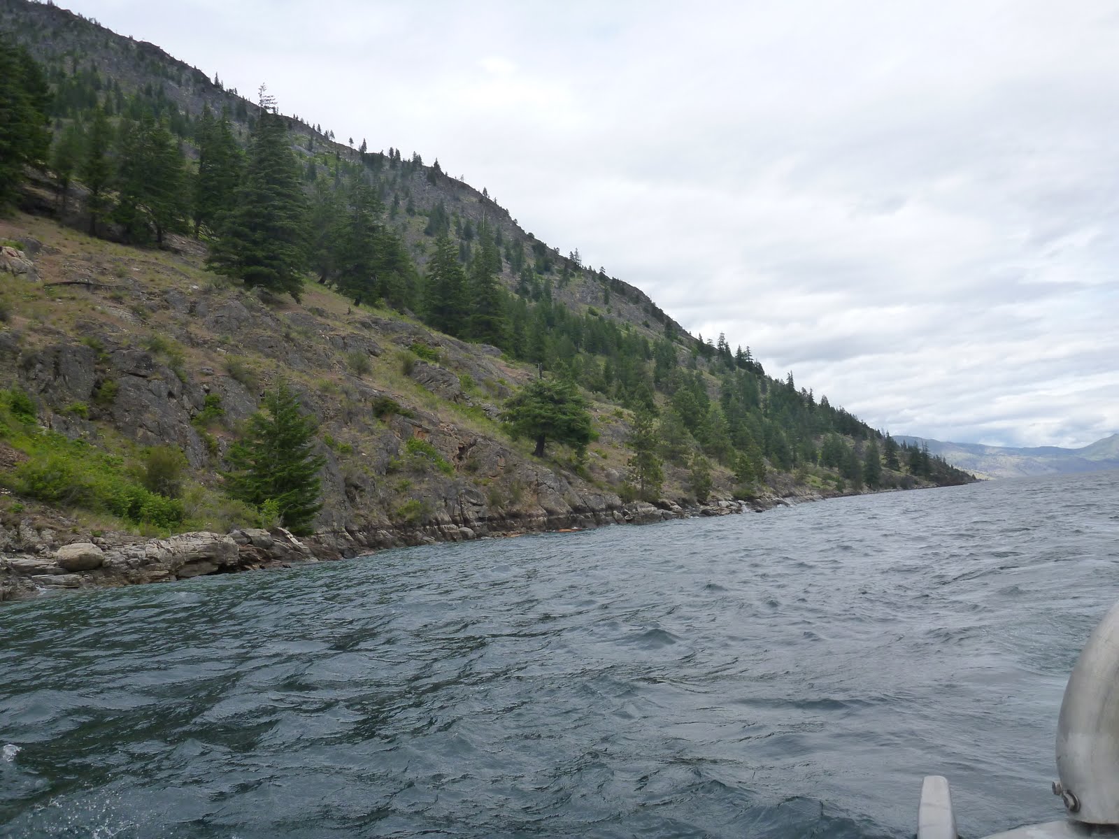

Views from the boat
Stehekin landing comes into view on the east side of the lake, the end of Lake Chelan in view as we dock. We disembark, carrying our equipment to the end of the dock to be staged into vehicles. Bill gives us some time to peruse the 'bustling' landing area. I go in to the gift shop but buy nothing, and I wander briefly up a hill to the NPS visitor center to see another topo relief map more concentrated on this end of the lake. After a bit I wander back down and see none of the Crew have come back yet. The restaurant is just opening so I go in and get a Sam Adams Summer Ale and sit on the deck outside. As I sit there 3 rafts of rafters are towed into the landing from the mouth of the river, all look like they had a great time, smiles all around.

I sit on the deck and enjoy the brew as I enjoy the view!
Howard comes by and asks about the visitor center and I direct him that way. A short while later I see that our bags are being loaded, so I put my beer bottle in the recycling bin and head down to put the equipment and food in the NPS pick-up truck. After everything gets loaded we hop in the trucks for a five mile drive up the valley to our campsite for the night. Bill explains some of the history of the place and points out the landmarks as we pass. The road follows the lake shore for a mile before passing into the woods and skirting the main river that fills the lake. I notice that many of the cars are old, still running but now infrequently seen. An old Ford there, a really old Datsun here. And sitting on front yards and abandoned in the woods are even older vehicles, the effect like stepping back in time. I suppose it is expensive to ship a car up lake so they keep the ones they have running for as long as possible.

Keep it workin' til a tree falls on it
As we approach our campsite, we come to an intersection, our road is on the left, across the river. We cross a very interesting trestle-style bridge to the west side of the river, and take another immediate left into Harlequin Camp. First Ranger Bill drives down and checks out the large group camp, he says when the water is up that camp can flood. We use the turn around and go back the way we came a few campsites to smaller ones that are a few feet higher. We get out, as we get out Josh realizes that Howard was left behind! We clambered in the vehicles and got out of Dodge (Stehekin in this case) without doing a head count. Howard was still in the NPS welcome center. Opps!!! After picking the campsite and unloading gear Bill goes back for Howard in his NPS SUV. We are going to be lent the pick-up truck for the entirety of our stay - very nice!
We all go about picking our tent sites and putting up our tents, hanging clothes lines, and organizing food somewhat. Liz has a zippable net bagging that we put some beer and wine in and tie off behind so tree roots on the river bank - the water is frigid and will keep these beverages at a good temperature.
As we setup our tents we ponder how Howard will react to being left behind. Will he be a good sport? Will he be mad? Not knowing each other we don't know what the reaction will be. Soon enough we find out. Bill pulls up and Howard hops out. He goes to Josh and says something along the lines of, "is this how you're going to run this trip?!", and then moves down a couple campsites to make his tent site away from us. Ouch! Not off to a good start for Crew continuity.
After setting up camp and conversing a bit, one of the girls (I can't remember which one, sorry!) came up with the idea that all of us go up there as a group, a beer in hand as an offering of peace. We roll up and he accepts the apology. We get an assigned number, which everyone promptly forgets (expect me, I was number 4!) but the important thing is we will now be very aware to look for six people of the crew before heading off!
Bill showed a couple people the airstrip, and more importantly where the showers are. We trooped up there to familiarize ourselves with the area and see two large yurts behind the shower house. We peak in the yurts to see cots, couches, reading lamps - the works! The yurts are for summer seasonal workers that do some trail maintenance and other Park jobs.

The leather chair was VERY comfy!
We aren't staying in these, but the showers are a nice enough touch. I came out here to backpack and sleep in a tent, I won't turn down a hot shower though! I was mentally prepared to not have any creature comforts at all for ten days.
The area between camp and the showers is a pleasant walk down a gravel roadway. There isn't much traffic. The structures around are mostly owned by the Park. There is a mechanics shop and a recycling yard. A water pump stands in a field for car washing. Attached to the shower house is a pavilion containing a couple picnic tables, a refrigerator, a large sink, and a microwave - all outside but covered by a roof. We use the sink, but nothing else. Off to one side of the field, the grass chest high and richly green, lies a very nice looking house with a fenced in garden and a bus that resembles the bus from 'Into the Wild' in the front yard. The mountains beyond the large trees in the valley floor surround and permeate everything here. One cannot help but feel those old hills bearing down. Any break in the trees or any meadow or open space provides one with a great view. The air is crisp and clean without loud noises to distract. As the evening shadows grow long, and being in the valley the sun disappears quickly but stays light long, the air turns colder very quickly.

Alexander "Super Tramp" not included
At camp we eat a dinner from the box of food. Josh and Joni did an excellent job of making meal plans to fit the stages of the hike. Tonight includes a salad too! The Park Service provided a 2-burner camp stove with a 5-gallon propane tank and a couple large pots and a girdle to cook on.
After dinner and cleanup Josh outlines the plan for the week. Tomorrow we have some clearing to do by the airport and then we start up Company Creek Trail with Bill. We continue to work with Bill Monday. Tuesday Bill is off and we work by ourselves. Wednesday is our day off. Thursday we backpack into the back-country to get a full days work without the commute on Friday. Saturday we come back to the valley in the evening and leave on Sunday. The meal weights and plan are built around this, and this way we get some back-country camping in there too! So we will get the best of both worlds - showers at the beginning of the week, wilderness at the end.
I am beat from a long day of travel. Josh and Joni are even more beat though - their travel from Minnesota was delayed in Seattle and they didn't get in to Wenatchee until very late the night before. We all headed towards our tents after an eventful day. I noticed that, though it was late, there was still plenty of light. Being so far north and so close to the Summer equinox the daylight lingers until 10 or 11 - I never did see it get dark, I always fell asleep before it did and woke up in the middle of the night to blackness. My tent welcomed me, the new Big Agnes down sleeping bag felt wonderful to get into as the temperatures dipped into the 50's.
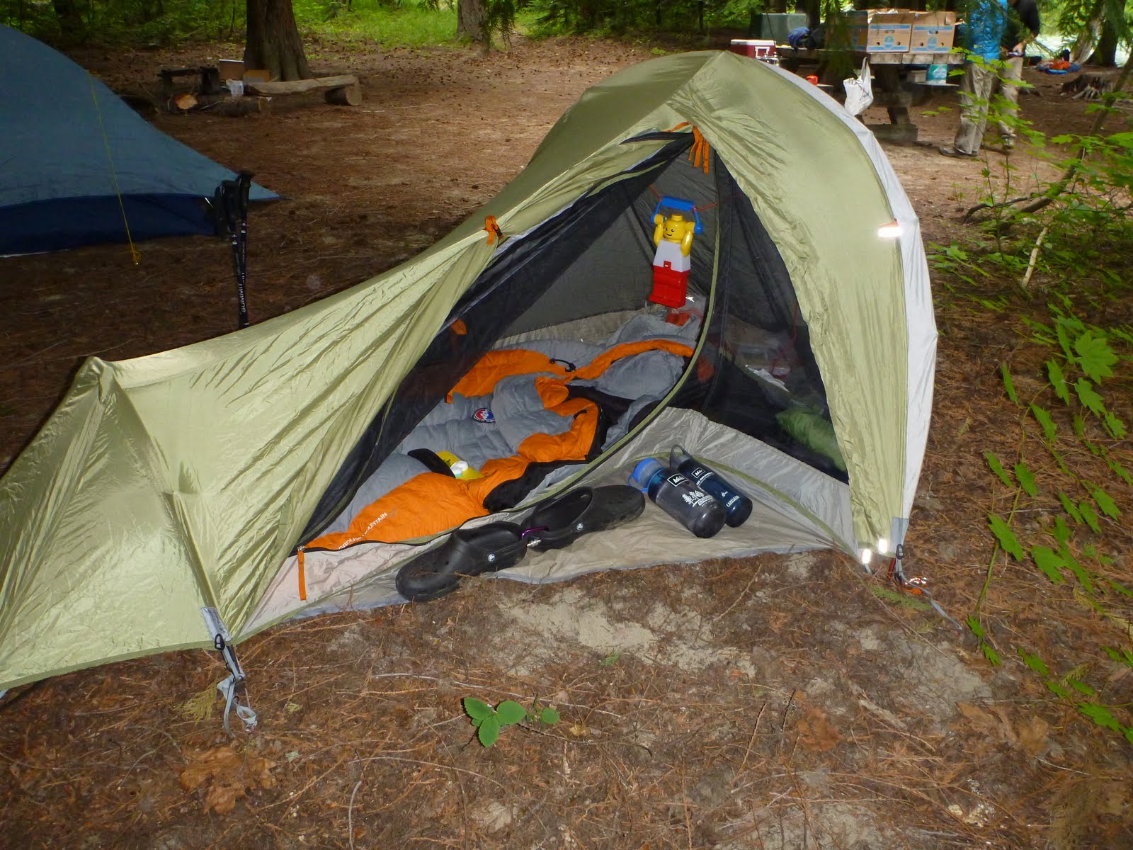
A small but comfortable home
This concludes Part 1: Getting There
Stay tuned for the next in the series as I go through my notes and write the rest! Next: Starting Work, Day Off, Finishing Work.
Thanks for reading!
