Trip Journal
10/9/2010 - Saturday
The flight from Baltimore took off on time, 8am. Jim and I landed in Kansas City, we were supposed to stay on the plane, however, after all other passengers had disembarked a mechanical issue forced passengers to Las Vegas off as well - another plane was going to be there in an hour. Both of us were hungry, so grabbed Quiznos sandwiches and waited to pre-board.
The second half of the flight was also easy. The pilot pointed out the Grand Canyon, Bryce, and Zion while on descent into Vegas. I finished reading ‘The Road’, that I had bought and started in Baltimore, seconds before we touched down.
On landing in Vegas we hurried down to claim our bags.The turn-style kept spinning and spitting bags, but ours weren’t to be seen. Eventually a Southwest representative came by and told us that some bags from Baltimore were left on the tarmac in KS. Now I was quite mad. We walked over to baggage claim, once at the desk I explained our situation, “You’ll hand deliver our bags to Zion tonight, right?!” Our two options were either wait for the bags and get $100 flight voucher, or have the bags FedEx-ed to our location... on Wednesday.
The choice was easy, Jim and I had errands in Vegas before heading North, and we didn’t have a firm schedule to be behind on anyway.
We grabbed the carry on bags and headed out to get the rental car. Fox is a discount rental car agency, very fairly priced. A bit more challenging to get to than the other rental car agencies. First one must take a shuttle from the airport to the rental car center, from there Fox runs a shuttle to their location.
Our chariot, quickly dubbed the compASS, wasn’t terrible. Manual everything, except gears, but we both are used to that. Plenty of room for all our stuff... once we got it.
There was a Bass Pro Shop close at hand, to pick up MSR Isopro fuel for the two camp stoves. After wandering around the enormous store the camping corner was finally spied. I also picked up the Nat.Geo. Adventure Road Atlas in case our path took us away from cell phone coverage (it never did for long). The Bass Pro has a casino attached to it, and a hotel. I’m fairly certain most things in Vegas probably have a casino attached - the 7-11, CVS pharmacy, PetSmart. Having 2 hours to kill, Jim and I decided to grab a bite to eat. An Italian restaurant beckoned. The restaurant was authentic and the sauce was incredibly tasty. I had the calzone.
We still had awhile to kill, so back to the BassPro casino to look at the sights. Inside we saw all the glitz and glam. At the far end a girl dressed like a mermaid swam in a giant aquarium, waving at guests and attracting a crowd. Shortly after this spectacle we left to head back to the airport.
I parked in the short-term parking, by a stairwell for easy identification of the car. Rather than going down and out, Jim and I ran up several flights of stairs to the top of the parking garage for a good view of the Vegas skyline. We slowly made our way around the top until reaching elevators that took us right to the baggage claim area.
Our bags were miraculously on the conveyor, we grabbed our gear and claimed our $100 from baggage claim. Off we scampered away from the lights of Vegas, away from the noise and confusion, into the darkness of the desert and mountains stretching to our destination some 3 hours north.
Highway 15 north speeds by the strip, many of their lights and billboards facing us as we tried to escape Las Vegas. The traffic wasn’t bad, though thick with idiots cutting and weaving for their intended exit on the strip. I pulled off at the last exit before the darkness, fortunately, in North Vegas, to grab a coffee and a lighter. I also bought a car charger with 2 USB ports and cig.lighter splitter. Jim didn’t bring a car charger, I was trying to help a brutha out. The iPhone snobbery threw a message “Not a supported iPhone charging device”. Nice Apple. Real nice. Dicks.
I entered the highway again. The Vegas lights almost immediately disappeared after on brilliant horizon stretching view as we rose on a bluff. The speed went from 65 to 75mph. The road went down to a 4 lane highway. I cruised into the blackened night. I had to pee and was weary of driving after an hour. I pulled down an exit and let a stream flow into the desert soil as I gazed up at a sky full of brilliant pin-prick stars. 94.5, a Nellis radio station stayed with us up into the mountains, cranking out sick Techno beats, pumping us up, and making the drive a rave.
Jim began the middle hour drive, the plains quickly turning into an upward sloping mountains climb, the mountains dark silhouettes, darker patches in a dark night, the slopes and peaks hidden from our view. Arizona mountains for 30 minutes, then Utah plateau. As we neared an exit and decided on refilling gas before getting off a major highway, Jim let it be known that on the east coast he had turned 30. Old man, now. He pulled into a gas station and I filled us up. I gave him a box that Heather gave me as his present. Contained in the box was a bottle of Johnny Walker Blue Label, unopened, and two engraved flasks, one for him, one for me. My pre-work had been filling our flasks with JWB from my stash at home. We were set on good liquor.
I clambered behind the steering wheel. And set out to SR 9, leading us away from the freeway and in towards Zion. Dark empty roads slid smoothly by, passing through little blips of towns, getting to Springdale and the south gate of Zion. The camp grounds Jim had called earlier was on the eastern border of Zion. The gate to the park was open, no one manning it to take an entrance fee. Our first trip through Zion was done in the cover of darkness. The road dropping away into nothingness, not revealing any splendor. We sped through hair-pin turns, and the mile-long tunnel. After passing out the east gate I turned left on the first available road, winding up some more elevation gain. Five miles later the Zion Ponderosa Resort was on the left. An information packet regarding our stay was taped to the front door of the office. We drove over to campsite 9 and setup our tents, both for the first time, by the headlights of the compASS. The mountain air had turned chilly, it was quite nice to have a warm sleeping bag to try out for the first time. I snuggled in with wool sock clad feet and quick dry clothing, I cinched the top of the bag, quite cozy in my nylon cocoon.

10/10/2010 - Angels Landing
I awoke at first light. The air was crisp and frosty outside of my one person tent, Jim’s Coleman borrowed from Tania set up close by mine. I put on some extra layers of clothing before climbing out into the sunny morning.
The sights that were hidden by the previous night stood out in sunlit brilliance. To the south highlands stretched out to distant peaks beyond several Conestoga wagon shaped cabins, to the west rose steeply a horn shaped peak beyond a nicely appointed cabin. The red and sand colored ridges shone in the mornings light. Behind our camp rose stunted pines trees meekly into the air, hiding other campers tents I had heard muffled conversation and bits of laughter the night before.

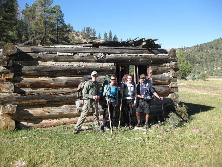
Legolas and the ‘pipe’ got a brief photo shoot.
Jim climbed out of his tent, the birthday boy. We walked down to the main office to settle the bill and see about breakfast. directly in front of the office, beyond some stairs and a fountain made to look like a stream, lay a putt putt mini golf course. This place really is a resort. Among some of the other services they offer, including: horse back riding, vehicle tours, and ATV riding. One can also rent a golf cart, if the 200 yard walk to camp is too far. Not really my style, but to each their own.
In the office we notice that our clocks are wrong, we aren’t early for the breakfast buffet. Las Vegas is in a different time zone than Utah. We stray into a herd of Bible thumpers while lining up for the buffet. The back of the line, “Can I get some Praise?!”, “Praise Jesus”, “God is good” responds from in front of us. We’ve stumbled into the midst of a church retreat. Eyes rolling, how petty of us, we find a table off to one side as Jim searches for a plug for his phone to garner a bit more juice.
While digging into our scrambled eggs, bacon, biscuits and gravy, and fruit we discuss our plan for the day. We want to talk to the park rangers about getting a back country pass, either to do the Narrows as a day hike today, or an over night, if that is possible, at that point we then need to find an outfitters that does shuttles in the town of Springdale. both the visitor center and the town are on the other side of the park so we must drive back through the myth and magic that went by our shadow clouded eyes.
Jim and I finish our tasty meal, pay up and walk back to the camp. We break and pack the campsite. Jim drives us back out into the day to the park. We toss some cash into the pot (he $20, me $5) for a entrance fee to Zion. The traffic was still light. We stop to peer at the Checkerboard Mesa, even the cactus enthrall us, as everything is new hidden by the shroud, our fresh eyes soak in the sights.

OMG a cactus!!
After the Checkerboard we see a bunch of Big Horn Sheep grazing by the road side! Shortly after we get to a line of traffic waiting to go through the tunnel. Apparently during the day the park service only allows one way traffic. There is a trail terminus here, but the trail is short and the tiny pull off unavailable. The traffic moves crawling through the tunnel - gallery windows open occasionally out over a vista and the Grand Arch, wind carved on a distant canyon wall. Beyond the tunnel the road gets rough, as it is being resurfaced. Down through hairpin turns to the canyon floor and over the Virgin River. Here we stop briefly to stretch our legs, let some traffic pass and view some more sights.
Next stop visitors center! We drove by the entrance and had to turn around, but it is accessible from either inside the park, or outside the park in the Sol Foods parking lot. We showed our vehicle pass at the walk in entrance and went to the back country desk in the visitor center building to inquire about our options. A plot formed while conversing with the ranger lady. We would get an overnight permit for the Narrows, we would stay in a campsite somewhere local and get a outfitter to shuttle us to Chamaberlain Ranch in the morning for a hike through the slot canyon. We were given the permit to camp at site 10, more than 8 miles the first day, and a foil and charcoal bag in which to poop in. We had to watch a ten minute program on ‘Leave No Trace’ and canyon safety. From here we went to the gift shop - I got a magnet, card deck, and a patch.
Jim and I set off to find an outfitters. We saw one before when we had missed the visitor center and had to turn around. Off to Zion Adventure Company! The charge for the morning shuttle was $30. After speaking with the outfitter shop girl I opted for some special boots with neoprene booties to keep the feet warm and have good traction whilst rock scrambling in the river. Jim soon followed suit. He additionally asked about canyoneering and why someone military trained still needed additional experience to repel on the higher level repelling outings. No response satisfied Jimmy. We did, however, learn and even got a crudely drawn map of some free campsites outside of town to the south on public lands. We had to watch a fairly funny after school special about the upcoming adventure, and were soon on our way to ‘downtown’ Springdale to look around and get some lunch.
A Tex-Mex restaurant caught our eyes and we lunched outside on burrito,chips, and salsa. In a gift shop I bought a friend some Springdale-made soap that smelled very nice. After dining we crossed the street to see how much hotel rooms cost. Too much for our tastes, we drove back toward Zion and stopped at Zion RV park. The campsites were $30 a night and we opted to stay down by the river in our semi-new compASS.
We left the car parked at our site and jumped on the town bus that took us one stop up to the visitor center, armed with bottles of water we jumped on the park shuttle bound for the Grotto stop and the trail to Angels landing. I ran out of water before getting there and jumped off at Zion Lodge to refill my bottle. In short order we stood at the bottom of the 5 mile round-trip 2500 ft climb of a trail. The first half mile wound along the Virgin, soon splitting from her shallow depths and rising through a series of long switch backs.

The short steep switch backs were still above us.
On our way up we spoke to a few guys that were also doing the Narrows the next day. There were many people coming down the trail. Two girls we would meet again, passed us going down on our way up. Many fewer people were heading up. In my pocket, I notice I’m carrying the soap gift I bought. Around my neck I wear the Labyrinth Necklace. After reaching Scouts Lookout, a flat spot where the West Rim trail joined from a different direction, the people heading down petered out. Chains began springing out of the rocks, the trail getting close to hundreds and thousand foot drops. The bus stop and road far below looked like ants trundling back to the nest. The chains lead us up the narrow bits of land to one more level spot before the final steep precarious push to the top.

The ridge is the trail!!
The view from the top was worth the sweat and effort. The exertion flew from our minds and our bodies. Bathed in soft evening sunshine, slanting from the west, the distance sides of the canyons glowed with a red radiance, the soft colors muting the harshness some cliffs shone with during mid-day. The peaks and ridges marched off into the distance into a velvety oil painting, edges soft.

View from Angels Landing
We had very friendly, nearly obnoxiously so, chipmunks come out to greet us, and beg for bits of food. Everyone must have watched the Leave No Trace video, the chippies went home with growling bellies, or more likely to nibble from full pantries of food others had given them.
Soaking in the magic ambiance for awhile, we decided to make our way back before the sun disappeared over the horizon, as we didn’t bring head lamps. Occasionally we ran or jogged down the easier parts of the trail, sometimes snapping a picture before making the way over a bridge, back to the bus stop. Back on the bus, we quickly made it back to the visitor center, just a hop skip and a leap from the town bus - driven by the hottest girl yet, according to Jim. We debarked at the first stop in front of the outfitters.
We went to Noodles and Pizza and sat on the front porch. We got a pizza with feta cheese on it, very delectable.
We set up camp and I was asleep before dark. I was exhausted, maybe jet lagged? The camp next door had a blazing campfire, and the guy offered us a hammer to drive our stakes after seeing our difficulty in the hard packed gravel site we were on. This was the most uncomfortable sleep of the trip, my hips feeling bruised the next morning. Jim opted to stay up and chat with the couple, he played dice with them long into the night.
10/11/2010 - The Narrows Day One
The shuttle for the Narrows left at 7:45am, so Jim and I were up early to pack our packs correctly for backpacking. I also needed my morning cup of coffee that I scored from a place across from the TexMex restaurant downtown.
I dropped off a post card at the outfitter desk, they were kind enough to mail it for me. Something about mailing a postcard seems more meaningful than a text or an email for some reason, sometimes the old ways hold more value.
While standing waiting for our transportation two girls came up and got on one of the buses. We were soon told that was also our bus. We sat inside and chatted with Jessica Brantely and Stephanie Duncan - Steph is an avid hiker and backpacker, while Jess had only one other overnight backpacking experience, most of her equipment was new. As we were talking Jim and I came to the silent agreement that they would probably need help. They seemed cool, and the conversation would be more interesting with new people. As we spoke, we gained insight that though they didn’t directly say, they were both spoken for, which is just as well, as Jim and I are also spoken for in a sense. This fact also made me more comfortable helping them if they needed it. Jess and Steph are both teachers in Arizona, Steph teaches 8th grades - a saint that one - and Jess 1st grades (i think).
On our way back through the park we stopped off at the terminus of the East Rim trail and dropped of the middle age couple. The shuttle took us past the Zion Ponderosa Resort and onto rough roads leading to the Chamberlain Ranch drop off. Mule deer kept bounding up the road ahead of us, finally flagging their tails one last time before disappearing down or up the mountainside. My bladder full, I got the bus driver to pull over and release me into the now frosty air - the temp really dropped with our elevation gain - and drained.
Soon enough we arrived at the trailhead, which begins on private property at the Chamberlain Ranch and follows a dirt road to the beginning of the Narrows. The dirt road starts on the far side of the small Virgin River (at this point), and continues for 3 miles to an old cabin before ending where the canyon walls begin to rear. The walk along the road was light and chatty, learning about the girls, and them about us. They had rented not only the water shoes but also the dry pants and wooden staffs. During the non-river walk the pants were rather binding, their packs bunching the elastic and pressing into their hips and torsos - uncomfortable and hard to relieve. The hour walk went quickly, we dropped our packs and had a pee and snack break before heading into the canyon.
Jim, Jess, Steph, me on the side of the old cabin.
The road ended quickly after the cabin our second river crossing began, and soon we were crossing back and forth over the river frequently. My booties immediately filled with water and stayed that way all day. The layer of water acted as a wet suit, warmed and kept my feet toasty and comfortable for the most part. I took the lead and stayed there most of the time, picking what I thought was the easiest route for myself and those following. I got good at it and we rarely got in past our knees. I think, I hope, I was a big help to Steph and Jess. I wanted their trip to be enjoyable, and I immediately fell into the guide/leader role. Jim took up the back and snapped pictures most of the time. I left my camera as the one he borrowed from Tania was water proof and shock proof.
The further we went south/southwest into the canyon, the higher the walls rose, soon spiraling into the sky far above our heads, making us seems o small and gloriously inconsequential! This part of Zion, due to elevation and temperature, also had wonderful fall colors. Coming around corners to see bright yellow clad aspen and deep red clothed maple trees was a treat beyond words. Occasionally the sun found it’s way into the depths and we reveled in the provided warmth.

The top of the Narrows were actually very narrow, unlike the bottom.
Our going slowed from a brisk pace on the road above to a near crawl in the river. The actual river crossings and walks, avoiding deep pools and treacherous unseen rocks slowed us, though the river wasn’t terribly high, so we shore walked quite often. We stopped for lunch in front of a perfectly red maple tree.

Other creeks occasionally joined our river, swelling her slightly each time. We came to a 20 foot waterfalls, with a very lucky and convenient side crevice around it. We snapped pictures from the bottom, and the antics of the girls getting over a fallen tree. Our spirits high we continued on. Several hours later, foot sore, weary we came to a side canyon as large as the one we were traversing. The water level doubled, and the creek became a river by Utah standards. We stopped very briefly for a snack and continued on, knowing the boys and the girls would be parting ways soon enough. We came to campsite 5, Jess and Steph’s home for the evening. Jim exchanged contact information, and we exchanged pleasantries of our fondness as traveling companions. We parted ways for good at this point.
Jim and I picked up our pace, slightly - as the going was still tough. But after all we’d been through we knew we neared the place wear the packs would be discarded for the evening. Buoyed by this, we made good time to campsite 10 and home for the evening. Our campsite turned out to be marvelous, the soil soft and sandy under a protruding rocky out cropping. My bed and rest would be great.
Jim and I made camp quickly, and had a meal in a pouch, with added beef jerky. While the noodles were rather bland, the cheesy sauce and jerky was fantastic. As the evening grew dark, each crawled separately into our tents and sleeping bags, the night air mild, the trilling of the river just yards away smoothly carried me away to a peaceful nights rest.
10/12/2010 The Narrows Day Two
Sometime after first light I awoke. I eventually climbed out of the tent and into the warm morning. During the night I had slept with the sleeping bag unzipped and the rain fly thrown open, as the temp was quite mild down in the canyon. Jim was out of his tent shortly, we had a leisurely morning, packing slowly. I had brought Huevos Rancheros for breakfast, they got burned a tiny bit so we couldn’t tell if they would be any better without the crispy flavor. Jim fried up half of our summer sausage, and that was the highlight of the meal - a dash of olive oil in the pan and the flavor of the sausage exploded. So delicious!
Our packs packed and gear stowed, I pulled on still wet neoprene socks and chilly water boots. After the first jump into the river, I get the warming layer of water. And Jim and I set off down stream, a couple people we saw yesterday closing in then falling behind - whether to give themselves the solitude or because they couldn’t go as fast we speculated on. The first mile seemed the most difficult so far. Cross this way, cross that way. Back track around a huge boulder to find a shallower spot, climb over a log jam, or up the side of a steep hill and follow a partially washed out trail. On one such circumventing side trail, the path abruptly ended at the top of an expanse of rock, about 45 degree angle. I sat on my butt and slide down, slowing myself with my hands. My middle finger on the left hand caught or jammed on something on the way down, and hot pain flared right in front of the middle knuckle. I cursed and shook it off and continued down stream.
Soon I noticed a foot-print heading up stream. And another and another, becoming more prevalent as we headed south. I knew we were getting into day hiker territory and we would soon start seeing them, because of timing and distance. Sure enough, or magic solitude and the wilderness feel evaporated as we came around a bend to a couple coming up stream. The canyon, and the true start of the Narrow, began to widen and fill with people. Many people had dry pants and staffs, also many people were lugging expensive heavy camera equipment, tripods, lens. And some had no day packs, no water bottles, even.
Jim and I were minor celebrities with the day hikers. “You overnighted in the canyon? wow!” Became a frequent exclamation. The canyon became wider yet, and the way became smooth, a virtual highway from what we had experienced with Jessica and Stephanie the day before at the northern end of the Narrows. Just to make it harder, a mile before river walk started, Jim and I made the pact to not leave the river until we got there - no shore walking, no matter what the depth, if we swam we swam. I finally got to my waist at one point, the first time during the trip.
After passing hordes of people, picking up trash as we went, mostly small pieces, but also a red rain poncho submerged in the river, we got the the end of the river walk, and the real end of our adventure, though I felt the end came with the first day hiker seen.
Jim and I dropped packs. I was hungry, he wanted to be submerged. I stayed with the packs as he scampered off to take a dip in the Virgin. As I leaned munching on dried fruits and nuts and eating a granola someone said, “You have a friend”, confused I turned and saw a fat gray ground squirrel at my shoulder, begging for a nibble. I shooed him, and he respectfully backed up. He and his friend returned soon enough, this time going towards my pack. I shooed, and he ignored me. It was very obvious he was used to people and not on the verge of starvation. I grabbed my hiking pole, placed the pole on him and slowly swept him away from my bag. I didn’t want to hurt the little bugger, but I did want him away from my stuff. I had to do this several times. He gave me a hurt pathetic look as I told him to shove off. They have certainly adapted, and know how to look cute to score some grub!! One guy pointed at a squirrel, and the squirrel stood on his hind legs and made little grabbing motions with his front legs - disgustingly cute!! Jeez!
Jim wandered back from the river, wet and satisfied. He did lose his sun glasses to the bottom of the river. Earlier I found a pair of female sun glasses that say ‘Smith’ on the side. Seems appropriate to hold on to them until I see Emily Smith again.
The two of us put our packs on and hiked the paved river walk towards the Temple of Sinewawa (sp) and the park shuttle. I took off the boots, poured out the water and put on my Crocs outside of the Zion Lodge a few stops later. Also, neither of us had used the foil excrement bags and needed to get ‘regular’ again. Ah, the joys of a flush toilette. Now back on the shuttle with drying feet, but cramped and standing, trying not to poke children and adults in the head with my pack or hiking poles! At the visitor center we decided to skip the second bus into town, as the first stop wear the compASS rested was less than a quarter mile. So after a stop in the Sol market we walked to the car, unloaded our packs dropped off the rented shoes and drove down to Noodles and Pizza again. We sat in the back corner of the porch so Jim could get WiFi signal from the dessert shop. While chatting with Heather, letting her know we made it out of the Narrows alive she fusses at me for continuing to be connected, feelings a bit hurt, so pushy, I sign off from google talk, and stop talking to her the rest of the time we’re out there; I continue using my phone while not in the backcountry, texting friends whenever I got the chance, her advise falls deaf on an addicts ears. I do like getting away from my phone, and do while in the Narrows, or while hiking. But while in town I like checking in with friends. The pizza was superb and the beer beer tasty. On our way out I went to the attached camping store and got a folding spork, as I found out I left my titanium spork at home. I went downstairs and viewed the art gallery, the photograph was some of the best I’ve ever seen... and priced accordingly! Next door I got some frog related knickknacks at the gift shop, and a coffee and some peanut butter fudge.
I drive us through the park. Our plan is to go towards Bryce Canyon and camp up there in or near the park. Bryce is a couple hours away, up SR 9 to route 89 north for awhile. The real Utah spread before us, small towns and fields in the valley we followed. The road was long and empty, gaining a passing lane on upward slopes, the elevation gain nearly constant, if slight. The speed limit went to 65mph, dipping to 40 through the towns. Many of the towns had shops selling rocks, there seems to be a fetish with Utah selling rocks - at one town there were 4 or more competing shops all selling rocks.
The day began to darken, casting long evening shadows upon our path. Jim and I discussed where to stay, and we came to the agreement of checking on pricing of hotel rooms outside of Bryce, as it was getting late. The thought of a hot shower after 4 days of not sounded fantastic. In the town of Hatch some cabins came into view roadside next to the hotel proper, prices were listed at $65 - not bad. The compASS needed fuel so I pulled into the gas station immediately around a bend of the first hotel. Across the street from the gas station was another hotel with an attached restaurant. After fueling, Jim ran across the street to ask about pricing. The price was similar to the other place so we decided to stay in room 3. After unloading the car, showering and relaxing for a few minutes, Jim and I went to the restaurant and ordered steaks. The proprietor was incredibly friendly, talking and picking on Jim. The two other tables of people in the restaurant were speaking some type of Slavic language, though I couldn’t place it. In short order, the steaks were brought, and they were huge! The mashed potatoes were tasty too. I ate only half of what was on my plate and saved the rest for lunch in Bryce.
We stayed up fairly late, watching TV, packing our gear in case we went on a back country over night in Bryce Canyon. The bed was wonderful, almost as desired as the shower.
10/13/2010 Bryce Canyon National Park
The alarms were set for pre-dawn. The chiming woke me and I bounced out of bed for another day of fun. Jim and I loaded the car, and into the very good, below freezing morning we strode. I put on long underwear and the zip down rain pants as well as several layers on top. The hotel gave us a 20% discount at a breakfast diner just up the road. Jim drove us there. The two of us were the only two customers in the diner, both of us ordered biscuits and gravy. We spoke for a long time to the man and wife that were running the place, as well as the older lady short order cook. The man had lived in the DC area for a bit 15 years previous and we spoke of the traffic and how much it has changed. These people were incredibly friendly and open. After breakfasting and chatting for awhile we got back in the car and headed for Bryce, still a half an hour distant. The morning sun crested the mountains, everything sparkled with a sheet of frost crystallized to every surface, a field full of diamonds!
The Bryce airport sat on the left before heading into the park, it’s windsock limp, no planes or runway visible. Prior to reaching Bryce, we drove through a state park by the name of Red Canyon. It was a miniature Bryce, small hoodoo, red ridges, a wash out, and interestingly designed roads.

Road through Red Canyon outside of Bryce Canyon NP
Beyond Red Canyon, Jim drove us into a small commercial district just outside the park. Ruby’s gas station, restaurant, market, hotel, etc ad naseum. stood on the right, more rock shops on the left. Jim pulled in. We did some lite shopping, picking up a few Clif bars for lunch, and Jim buying a giant bottle of Ibuprofen as we had already demolished the supply he had brought in the first aid kit. We got back in the park and headed for the visitor center, I paid the $25 to get into the park and we drove past the visitor center and had to turn around... you see a reoccurring thing with that?

After waiting in line to talk to the park staff about back country camping, the ranger gave the same advice as the ranger in Zion - Bryce Canyon Under the Rim Trail just isn’t that impressive, if picking between the West Rim of Zion of Under the Rim of Bryce - GO to Zion! Not one to always take advice, I walked away with no definite plans. I wanted to really see Bryce to try and get a feel for it before buying into advice, but still weighing the advice to make an informed choice.
We left the visitor center and drove down the main road into Bryce - there isn’t much the the park. One road travels along the rim with overlooks down onto the hoodoos and natural bridges and other distance vistas. The first overlook we stopped at, just after Bryce Lodge, was fairly busy with tourists, not many of them spoke English.
The views were other worldly, almost like looking onto Martian terrain. The structures fantastic. Row upon row of phallic hoodoos, stretching into the distance. The mind is left wondering, how are they formed, why are they formed, is it possible to walk down there amongst them? Do they ever fall over?

Thor’s Hammer
A trail lead over the cliff edge, intrigued Jim and I walked back to the car and but on boots. I left both long underwear and long pants on and almost immediately regretted it. I also carried a day pack with some snacks, clothing, compass, map, and 3 liters of water. The trail began steep, and we stopped often on the way down to take pictures. There were quite a few people coming down and returning up the trail. After a series of sharp switchbacks we came to a split in the trail, “Peekaboo 3 mile loop” and something-Queen. Peekaboo Trail looked more interesting so we went that route. After a bit further, we got onto the loop itself and followed it to the right. After a couple ups and downs, and many pictures, I saw foot prints and the hint of a trail leading off to the left. Knowing that it would be impossible to get lost in a loop trail if going left, I followed the side trail around a precarious ledge over a shoulder and into a hidden valley. The main trail was becoming boring already and the thought of off-trail made it seem like I was in the wilderness again, tracking someone. The tracks I saw were going the same direction I wanted to go, and only in one direction. I thought it likely that over that next bluff I would either find the body belonging to the tracks in some deep dark crevice or I’d find the trail again. It was the trail. We clambered back onto it and continued on the loop, saying “Hi” to a couple as they passed. A little while longer I decided to off trail again and follow a wash down rather that the trail. After a bit I noticed there was a tiny stream of following water in the bottom of the wash. Bryce Canyon is much more arid than Zion - I had already drank a liter of water. The sun was blistering, and yet a chill in the shade often took hold. Following the wash, the trail merged back in and we continued. The same couple before saw us again and were momentarily stunned, “Either there are two guys that look just like you or...?”.

I see a heart!
Peekaboo trail terminated, we probably cut a bit off with our off-trailing, however, the sights and feel of wilderness was worth it. Hiking to the Rim behind a long line of students on a school trip was trying. My legs and me bum quite sweaty due to the paints and undies. I finished another liter getting to the car.
I went into the bathroom to change. Jim put a few shirts and most of his wool and poly socks on the roof to dry faster after rinsing them in the sink the night before. We sat in the vehicle eating lunch - I finished the mashed potatoes and steak from the night before, then put the folding spork in the console. We laughed at the foreign tourists that seemed to be more interested in a shy chipmunk than the grand magical views a few hundred feet behind them.
Lunch finished and our minds leaning toward going back to Zion to try and get a permit for the West Rim the following day, we started the compASS and continued the touristic drive and overlook stop down the Rim of Bryce Canyon. Going by ‘Inspiration Point’ I saw a backpacker road walking. I told Jim to pull over and offered him a ride to his car. He jumped in and we drove the 3/4 mile (hey it’s something!) to the parking lot. He just came from a partial completion of the Under the Rim - he said it was pretty, and he liked it and would suggest it, though the southern section had little in the amount of vistas. Even with this advice, we were set on going back to Zion. There was something about Bryce that was kinda blah. Maybe the hordes of tourists, maybe after the initial shock of the hoodoos wore off, maybe the vistas too distant, or maybe just pale in comparison to Zion. Whatever the case, we were quickly boring ourselves with the stop and shop tourist overlooks. Our last stop, at a Natural Bridge, we determined to head back to Zion to catch the back country desk and get a permit for the Zion West Rim, we thought it closed at 8. We didn’t even make it all the way down the Bryce Canyon Rim Road - we ran out of interest, the views getting more mundane. We stopped by the visitor center again on our way out and Jim went in to get a few things while I sat in the car.
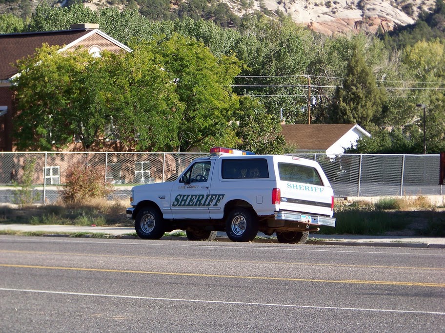
The drive back to Zion went very quickly, at one point Jim pulling over so I could snap a picture a hella-cool cop car.
Back down the valley, through Hatch, and the other small towns, onto SR9 and soon enough the east gate of Zion came before us, then behind. A short wait at the tunnel and we were soon enough back at the visitor center. While I was in the bathroom Jim realized the visitor closed at 5pm and it was 4:55. He ran to the back country desk. I walked in behind him as he and the ranger discussed the West Rim. We reserved a permit at campsite 7. The man that had walked in seconds after Jim could not get a permit, as we had gotten the last one. The plan was to get a private shuttle from Springdale to the Lava Point Trail head of the West Rim Trail, walk the trail back to the Grotto and take a shuttle back into town again on Friday. Next stop - the outfitters. After Jim insisting we call around for pricing, no one had shuttles available until 10 or 11 - we wanted to get on the trail earlier - everyone else referred us back to Zion Adventure Co, the old go-to. Our time was set to go at 7am, a 6:45 meet up time at the outfitters.
Jim and my home for the evening was the Zion RV park, directly across from the outfitters. We got a sight back in the corner, with some soft soil to put the tents on. We setup our tents, and began moving things into them. Jim starts spazzing around looking for something. Apparently he left those clothes on the roof at Bryce and drove off, letting the wind scatter them in the breeze. Neither of saw them fly. Jim had only a pair of liners now. No wool socks. I offer my pair of Alpacas, he refuses and stomps around. We were planning on making spaghetti and sauce, as it was the heaviest meal yet. I am getting the ingredients out, hoping to beat the darkness. At this point Jim can’t find the car key. He start looking and re-looking for it in his pack under the tent in his pockets in the back of the vehicle by the spare tire - to no avail. He starts saying “This is a sign, kismet, I’m not going tomorrow, something terrible will happen.” I try and calm him. It doesn’t work. Finally he finds the key in his large duffel bag and throws it at me, lightly. I almost say a jib and hold my tongue, knowing the Irish is pumping. Still in a ruffled state, he throws his backpack in the back of the car and goes for a walk.
I choose not not make the pasta, as it’s labor intense, and currently evening is falling fast. I don’t relish the thought of cooking by head lamp. After a few minutes I decide to walk to Sol and get something to eat. After purchasing sandwich fixings, soft drinks, and tortillas for the huevos (hoping to make them better) I head back to camp. Jim was sufficiently calm at this point. We make sandwiches by head lamp and save half the cheese for the sausage for the next days hike.
I called Dad to wish him a happy birthday and chatted with the folks for a while. Then I called Kevin and talked for a bit too. Jim was over in another camp charging his phone and camera off of an RV ‘hitching post’. We filled our water bottles and packed as much as we could before settling in for the evening, alarms set for 5:30am. I slept ok, but kept having thoughts of tarantulas crawling on me.
10/14/2010 West Rim
I woke before my phone alarm, hearing Jim getting out of the tent to pee. Shortly after my alarm went off and I began packing. Jim follows suit and we finish at the same time. We put the packs in the car. I drive down the street to get coffee, and flirt with the coffee girl. She hesitantly asks if I’m a local. Nope! I wonder if I would gotten a discount on my coffee if I’d say yes... or if she wanted my number. I’m going with the former answer!
I park right in front of the outfitters before the shuttle or anyone else get there. Jim can’t find his purple Nalgen and walks back down to our campsite to see if he left it there. As he leaves the shuttle driver lets me know she is taking the shuttle down to fill with gas, so it would be a few more minutes.
Another lady pulled up, a day hiker for the West Rim, just as Jim and the shuttle get back. Jim’s water bottle was in his pack the whole time, no wonder the food bag was so heavy! We toss our stuff in the back of the van and head out. First we swing by the visitor center before heading southeast away from Springdale and the Park entrance. Just after Virgin we turn right and get on a road that intermittently is in the park or a state road. During the ride I learn the two guys are software engineers that both know NetApp fairly well. We have a nerd conversation and Jim understands a bit better how it is for me around a group of docs talking shop.
Eventually at the trail head at Lava Point, down a rough dirt road, we all hop out and thank the shuttle driver. She leaves us to it. The woman day hiker disappears quickly and is never seen or heard from again (at least by us).

Jim and I set out into the wilderness
The ground is fairly level, slightly rolling hills, never deviating more than a topo line. Jim and I make good time, eating up the miles. A mile in we stopped and shed extra layers. There had once been a fire here, some stands of larger trees survived, but mostly low second growth trying to reclaim what was destroyed. Out to the west I could see higher mountains. Sometime looking west, the green forest and burnt out section almost resembled a clear cut and blue ridges of the Appalachians. To the east, when getting to the rim, it certainly does NOT resemble anything on the east coast. The deep steep canyons cutting between red and sand colored sheer mountains, crowned with a bit of green. I stopped often for pictures, Jim and I alternately leading and following. As the trail got close to a very steep drop off we slowed for a break, drinking and taking pictures. Looking at the map, it seemed we had less than a mile to camp, and it was only just before 11am. The two guys caught up with us and we chatted for a bit. They had heard that campsite 4 was large enough to accommodate a large group, so if we wanted to stretch the day longer we could press on to that camp. It was a thought, we would decide after we saw our supposed home.

Jim on the brink

“a golden field, that came up up to beyond our chests”
The last mile went fast. The trail turned away from the Rim and followed a low point between two hills, descending consistently into a golden field, that came up up to beyond our chests, through a stand of dead trees. Soon we reached camp 8, where a spring was located. Around the corner a few yards, camp 7. We turned up the dirt path and found a bit of shade. Jim cut up the cheese while I cut the sausage - a nice lunch in the shade of a large pine. After mulling the issue, we both agreed we liked the campsite and would stay here, rather than going to campsite 4 and taking our chance. Plus there were some hills around that looked like they would be fun to explore - packless!
Jim and I climber the conical looking hill behind camp, dodging cactus and bushes, looking for rattle snakes, but seeing only lizards. From the pinnacle a nice very of the valley opened up. Beyond where campsite 8 and the spring was supposed to be and canyon quickly formed, dropping into nothingness from our point of view. The valley below, clad in yellowed aspen leaves, and golden grass swaying in a gentle breeze, stretched below north to south. The northern end ascending around the hill across the valley floor. Evidence of fire lay everywhere. Strangely there were many dead trees laying down, all in the same direction. What added catastrophe, beyond the fire, made all the trees lay at the same angle? A tree stood on near the top that looked like a woman spreading her legs, a treegina, if you will... ok, i may have been in the back-country too long already. From the vantage, I spied several hikers creeping by on the trail, day hikers by the looks. Even at 10x zoom they were small and distant, but stood out in strak relief to the golden brown valley. The descent from the hill took Jim and I on a meander course back to camp.
We lounged around for a bit, then set up our tents and kept getting yelled at by a chipmunk. Knowing he and his friends were around, we decided precautions would have to be taken when leaving camp. After setting everything up I poured all the water I could into the Platypus, Jim did the same. We went looking for the spring, pump and empties in hand. The trail to camp 8 wound through a meadow. A large pine tree on our side of the creek seemed to have some matted down areas in the grass, though no dirt areas or rocks for cooking; still, we assumed that was campsite 8. We continued following the trail down into a marshy area. Off to the right a pond hid beneath the grassy shore line. From the left, the mouth of the spring could be heard trickling. A small pool with minimal algae could be seen after pulling back some grass. I got the pump setup, Jim straddled the spring fed pool and held the hose of the pump away from any muck to save the filter from unnecessary blockage. The 3 liters of cold water quickly filled our Nalgens.
The water toted back to camp, and stowed in the shade, Jim and I followed the trail in the opposite direction from whence we came. Almost immediately the trail slopped up the hill across the valley. We followed the trail up, passing two backpacks on the wayside, maybe the people went back for water, but there presence wasn’t apparent. Towards the top of the rise, where the trail began leveling off the valley behind became visible. I snapped a couple pictures of our camp from afar.

Campsite 7 - on the West Rim Trail
Jim and I could see the hill before us dropping of into something, while the trail curved to the right, we opted to off trail straight ahead. The land began sloping down, and soon became to steep to continue. Before us the ground disappeared, the bottom of the canyon invisible from this angle. We decided to follow it to the right, as it looked like the canyon petered out between two hills. We paralleled the trail and the canyon until it seemed like it would be safe to get into the canyon. A small dip in the hill was the beginning of the canyon that 300 yards away was thousands of feet deep. We followed the tiny dip. Soon it became a bit deeper, like stream embankment sides, though no water apparent. Deeper still, and soon a 15 drop off. This would have stopped our descent, but a huge old pine had fallen into and across the, now, ravine. Jim opted to monkey crawl out on to the tree from a limb and down the other side. I dropped down holding on to the same branch, dropping a few feet to the ground below. Further on we came to another such drop, except 60 or 80 feet, with no chance of going further. A small meadow opened on the next step down, with what could have been an animal trail. With no safe way down, we just stopped and basked in the view of our hidden valley stretching into the depths and the distance before us.

Not many see this view
A hard climb up the hillside brought Jim and I back to the trail. While on the hill we could view some interesting looking canyons around and behind campsite 8 and the spring. We determined that as our destination. We headed down the hill, passing a group of 9 Utah natives headed up and to a campsite down the ridge, they looked to be scout, or some type of youth outdoor group. A quick stop at camp to get rehydrate and grab a snack, and off we went to the next place for exploring.
A trail flowed around the spring and continued back towards the main trail, directionally, but ended at the true campsite 8. Hidden from view of both trail and spring. The first large pine and matted grass would have surely thrown us off, and had obviously tricked others as well. A side trail from the camp trail lead down the left side of the gorge, beginning where the pond leaked over the rim in a flowing cascade and disappearing into the canyon depths. Below and waterfall sounded from the depths. This side of the gorge was arid, with a few low trees cactus and open ground. The views were incredible stretching away to a huge arch, and the bottomless canyons wending below the vantage. Going back around the the other side of the canyon lead us through a marshy soggy section. The other canyon side was lush in comparison, high grasses, taller trees, low bushes, and no open ground. The view was just as spectacular, but not as easy to get to the rim edge. I did spy the cascading waterfall, though hard to see, a picture would not turn out, it almost seemed the water fell through the rock into a grotto or cave carved into the head of the gorge.


Our tummy’s telling us it was time to head back to camp, the jerky we’d been munching while exploring this gorge not sating us. Jim and I headed back to camp, cutting across the meadow fronting camp 8. On the menu for the evening was wheat spaghetti with olive sauce. Additionally a entire yellow onion to fry. And some bread to sop up the leftover pieces. While Jim began frying half the onion I began boiling the water for the noodles. Each of us had a stove and fuel to use, Jim using the one Heather let us borrow, I was using the PocketRocket. The campsite had some rocks to act as a wind break for cooking, even then if Jim turned down the stove enough to not burn the onions, it had a chance of blowing out the flame. Watching this a few times I came to the conclusion that I would need to find or mod the PocketRocket a light weight wind bib of some kind to save fuel and headache on a windy day. That day wasn’t terribly breezy and was having a large effect on the cooking experience. Jim, being a prima dona, insisted the sauce be ‘cooked’ in a separate pot... personally I would went the ghetto route and added the cold sauce to the hot noodles and mix for warm sauce and noodles... but that’s just me. Regardless, after 40 min of pot management and onion juggling, the meal was finished. I devoured mine as quickly as possible. I didn’t want any leftovers, besides it was tasty!
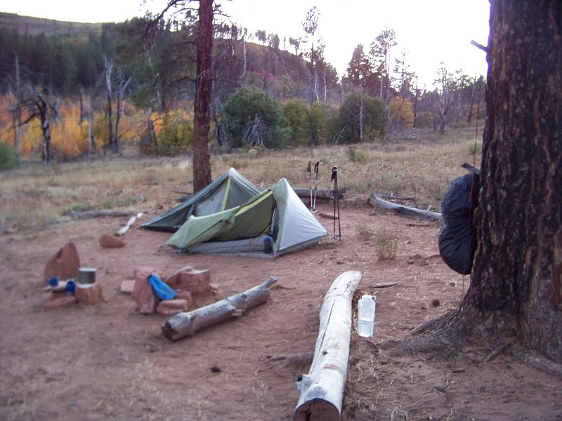
Home Sweet Home
The evening was darkening, the sun fading quickly. The top of the conical hill still had warm orange, the shadow slithering up the sides of the hill, eating the light from rock and bush. Nature called and I grabbed the trowel and TP. I went up the hill, looking for a pooh with a view. The soil was so soft, free of roots and rocks, the cat hole was easy to dig to the requisite depth. I did my business, while Jim was down in camp throwing big branches at bigger branches because it made a noise... interesting fellow, not really a prescriber of the “Take Only Pictures, Leave Only Footprints” No Trace ideals... I satisfyingly saunter back into camp, while the paparazzi takes my picture of trowel and TP in hand.
After cleaning all the dishes, stowing all the smellables, and hanging the bear pinatas the temperature sank with the sun. The light faded, and I crawled into the tent, quickly and comfortable falling asleep on the soft ground.
10/15/2010 - West Rim Day 2
I awoke at first light, before the sun had breached the peaks around the campsite. I crawled out of the fabric cocoon into the cool morning air. In the distance the sun broke over the far peaks and hid behind some clouds, the first I’d seen on the trip.
Jim crawled out soon after. We were in no hurry. I made coffee. Then we grabbed empty water bottles and sat in the dewy grass around the spring to fill four liter bottles.
For breakfast we tried the dehydrated eggs with BBQ chicken from a pouch and hot sauce folded into flour tortillas. It still wasn’t that good.
Slowly we broke camp and packed our packs. The sun coming up and out, warming the air. I took all layers off before heading out, knowing I would warm as I walked, especially knowing of the incline on the other side of the valley.
Jim and I set off up the trail, and up the hill. Not strangely, it was much more strenuous with a full pack. We went across the flat spot on top, and then ascend the adjoining hill, doubling the elevation from the valley floor. Upon reaching the next level spot, the trail followed the rim again, giving views to the east and Zion canyon proper. We followed the ridge gazing out at the views for awhile, and then ascending more.

Jim on a switchback
On the highest part of the rim so far campsites 5 and 4 were situated. The wasn’t much cover, not much to explore. Campsite 7 was much better for us, if only for the amount of things to explore around the camp. I would not want to be in either of those camps during a thunderstorm! The trail continued on the edge of the rim. I gazed out into the beauty of Zion and did not regret the decision to be here. The only wildlife the made it’s presence known were the hordes of lizards scampering before my feet.
Camp 3 was on slightly lowering ground, in a sparse forest. Camp 1 slightly lower still. In the distance, only valley floor, I could just make out a path carved into a hill, winding off to the right, around and out of view of another bluff. It looked to be the trail leading to Angels Landing, and still 3 miles distant and several thousand feet down. We came to a shaded intersection, with a sign for a spring 100 yards down a path and a sign pointing towards Angels Landing. Jim and I broke for lunch here, munching trail mix jerky and Clif bars.
A day hiker proudly walks up the trail from the downhill side, expressing her happiness to have made it this far, and goes to check out the spring after conversing for a bit. A man that Jim and I met earlier, who had overnighted in site 2 and had come in from the bottom, comes to the intersection, and that’s when I notice campsite 2 is also located here. He doesn’t like the clouds and is packing up and heading out in case weather is coming. We discuss a booming we heard yesterday, not as thunder, but more probably as dynamite from a strip mine adjacent to the park.
After lunch the trail starts descending from the high country in earnest. The next mile is carved into a cliff face, going through three long switchbacks. We are eventually deposited in to a canyon floor, shaded. A few perspiring day hikers and rock climbers passing us going up.

Down, down, down.
The environment becomes more desert like, at time the trail is sand, other times it is poured on concrete to prevent erosion grooved to give traction. After winding up a couple small canyons, the trail leads up a steep hill, regaining some lost elevation. One final push up a sandy trail took us to a rocky open expanse, marked with signs. In the distance Angels Landing can be seen. Though the people on top are hardly visible, I occasionally see a glint of sunlight from a reflective object. As it looms closer the movement of the people becomes more apparent. It looks crowded.

The last of the wilderness
A gentle hill going downwards, with Angels Landing viewable in the near distance, with Zion canyon as a back drop. I chatted with a couple from Portland Or. Jim stopped to take his boots off and go barefoot, either because his feet hurt, or he wanted the attention, probably a bit of both. I began developing a blister on my right heel from all the downhill, and limp a bit to avoid rubbing the same place.
As the trail rounds a corner to Scouts Overlook I see many people, sitting in the shade, winding up from below or coming down from Angels Landing. Back to the land of crowds after over 24 hours of not much interaction.
I am surprisingly gregarious on the way down. I walk slowly and talk to people around me, telling about the overnight trek I’m coming back from, over being related their tails of backpacking adventure, I explain who Legolas is, and why I’m limping. Jim goes faster down the hill, soon out of sight. The steep way down is made quick and enjoyable talking to different folks. Back over the bridge at the shuttle stop, the first one we let go as it is too full. The second is also very full, but Jim and I manage to wedge ourselves in. At the Zion Lodge stop we must get off to allow people sitting to exit. We both get seat. Mine is at the front of the tram, a couple women sit next to me and I chat with these Montreal girls I apologize for probably smelling bad, since I hadn’t showered in a few days. One said, “Don’t worry, you don’t smell too bad.” I guess I did smell, just not much. Quickly enough, my knees aching, from kneeling on the floor and having my pack on the seat, the shuttle arrives at the visitor center, one last time. Jim and I get off the shuttle and walk back to town along the road to the compASS in front of Zion Adventure Company. Our gear stowed, we again head to Pizza and Noodles for a bit to eat and I a beer.
After finishing we leave Springdale, again for the last time, heading back to Las Vegas, seeing the sights we had not seen during the night of our arrival. I marveled at the mountains in Arizona and the gorgeous nothingness of the desert below as a brilliant colorful sunset behind mountains far far away.

As an interesting aside, Heather and I met and talked to a guy on Old Rag that fell of Angels Landing, or rather fell from the above pictured switch-backs. Apparently he and friends were playing with a boomerang and it got stuck between switch-backs. He climbed down to get it and messed up his back pretty badly requiring a hospital stay. It's a small world... but also great to see him on Old Rag not letting a fall stop him from enjoying some rock scrambling.
ReplyDelete